
The commercial power frequency in Japan is 50Hz on the east side and 60Hz on the west side, bordered by the Fuji River.
The reason why the east side became 50Hz is because TEPCO built the Asakusa Thermal Power Station along the Sumida River and installed a German-made 50Hz generator. Today, the site of the Asakusa Thermal Power Station is now the Kuramae Substation.
As I walked along the Sumida River, I was determined to find the Kuramae Substation.
Senju-Ohashi Bridge
I got off at Senju-Ohashi station to continue walking along the Sumida River.

View from Senju-Ohashi Station
This is a picture taken from the station platform looking south. The cleared land in front of the station is surrounded by a tiger-patterned fence. I wonder if they are going to build a building in the redevelopment.
The Senju Bridge can be seen beyond the vacant lot. If a building is to be built, the bridge will eventually disappear from view. When that happens, this photo may become a valuable one.
Slightly to the right of the photo, you can see a hexagonal building with a sloping roof. This is the head office building of Senju Metal Industry, famous for its solder materials.

Adachi Central Wholesale Market
First, we took Route 4, aiming for the Senju Bridge. On the other side of the road, you can see the Adachi Central Wholesale Market. It is the only wholesale market in Tokyo that specializes in marine products.
The market was closed today, and a motorcycle training class was being held.

Sekido Museum
On the way from the market to Senju Ohashi, I wanted to see the Sekido Museum of Art in the Senju Metal Industry headquarters building, so I changed course.
This time, however, I was disappointed. It was a closed day.

Senju Kobashi
I regained my composure and crossed the Senju Bridge. I could see the Senju Kobashi Bridge under the bridge. I wanted to cross the Senju Kobashi Bridge as well, but it was a long way off, so I gave up.
Shioiri Park

Hie Shrine
Just after crossing over to the right bank of the Sumida River, there is the Hie Shrine.
A sign here says, “Sanno Seibei, who committed seppuku here because he could not bear the pain of tooth decay, is enshrined here. However, on closer reading, I found out that he is not enshrined in this shrine, but in a small shrine about 90 meters south of the shrine.

Tooth God Seibei’s Small Cave
This is the small shrine. It is said to be beneficial for toothache.

The promenade on the embankment
After passing through the Joban Line, a promenade appears on the embankment.
On a sunny day like today, neither too hot nor too cold, it is unquestionably pleasant to walk here.

Senju Shioiri Bridge
This is the Senju Shioiri Bridge. I was tired of seeing only arch bridges upstream from here, so the simple girder bridge felt fresh.

Shioiri Park
Shioiri Park looks like a foreign park with its well-balanced arrangement of trees.

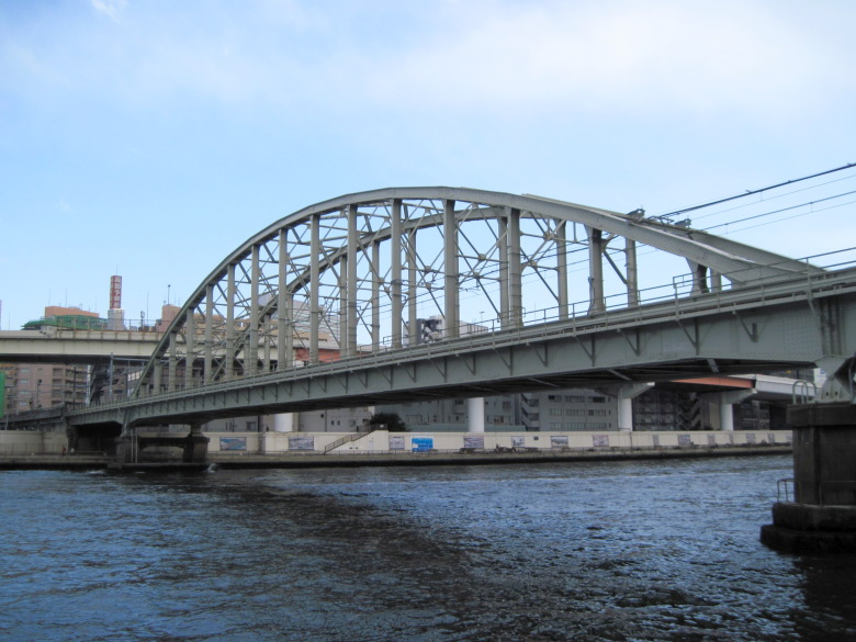
Suijin Bridge
At the Suijin Bridge, we went back to the lower road arch bridge. Does the fact that the Lower Road Arch Bridge is very popular mean that it is low-cost and strong?

Zuikou Bridge
The Zuiko Bridge is a bridge over an inlet of the Sumida River. This inlet was once a canal leading to the Sumida River Freight Station, which was established as a coal collection point.

Ruins of Shioiri Sluice Gate
The remains of the Shioiri Sluice Gate are still visible above the cove. It was in operation from 1953 to 1970 to protect the surrounding area from flooding.
The Google map shows the Masaki-no-Zeni-za site in this area. I was curious to know what kind of facility it was, but I couldn’t find it.
Kototoi Dango

桜橋

Shirahige Bridge
Soon we came to the Shirahige Bridge. It looks more bulky than it should. But I don’t hate it. It is attractive.
It seems that the Hashiba ferry where Ariwara no Narihira wrote the poem, “In the name of the bird, I will ask you if there is anyone who thinks of you.”
Soon we came to the Shirahige Bridge. It looks more bulky than it should. But I don’t hate it. It is attractive.
Ariwara no Narihira said, “If you have the name of a city, then let me ask you, O city bird. If you have the name of the capital, I will ask you, O bird of the city, whether the person I love is safe or not.” It seems that the Hashiba ferry was located in this area.
Sakura Bridge
The Sakura Bridge has an X shape when viewed from above. But from the side, you can’t really tell that it’s X-shaped or that the sides are curved, and it looks like a surprisingly ordinary bridge.

Sumida Park Youth Baseball Ground
I crossed over to the left bank at the Sakura Bridge and went back upstream a bit, where I found the Sumida Park Youth Baseball Field.
It is said that Oh Sadaharu used to play here when he was a boy. It is obvious from the relief on the gate.

Kototoi-dango
I crossed the bridge to the left bank to see the Kototoi-dango (Dumplings) sold at a store next to the baseball field.
In the past, when there was no cell phone in this world, I looked for a store selling Kototoi-dango around Kototoi-bashi Bridge, but I couldn’t find it at all. I couldn’t even imagine that there was one between Shirahige Bridge and Sakura Bridge. In the first place, if Narihira’s poem was the origin of the word “Kototoi,” they should have named the bridge “Kototoi Bridge” instead of “Shirahige Bridge.
Anyway, I’ll buy some today and go home.

Kototoi Bridge
This is the Kototoi Bridge. You can hardly see them in the photo, but there were a lot of city birds (gulls) flying around. I wondered if they were feeding them from a boat.

People enjoying the leafy cherry blossoms in Sumida Park
At Sumida Park, there were many people enjoying the leafy cherry blossoms.
Yes, I saw many foreign people wearing kimono. It would be more elegant if Japanese people wore kimonos to enjoy the cherry blossoms.
Azuma Bridge
The Azuma Bridge and the Asahi Group buildings behind it both exude incredible power.

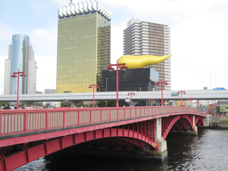
Komagata Bridge
I thought the Komagata Bridge looked quite different, but it seems to be undergoing a lengthening project.

Umayahashi Bridge
The rivets on the Umayahashi Bridge also give it a semi-heavy look.

Public restroom by Umayabashi
Near Umayahashi, there was a public restroom with a face design. I wonder why it was a face. Is it a victory to stand out?
Kuramae Substation (former Asakusa Thermal Power Station)

Front of the facility
Today, I found a facility I really wanted to see! It’s such a magnificent building, but there’s no sign on it. No, actually, there was a sign that said “Let’s make our town beautiful” and the name of the facility was written on it.

Side of the facility
If you go around to the side, it looks like this. It looks like a water treatment facility in the backyard of an aquarium. But it’s not.

Kuramae Substation
I went around the back and found a massive electrical facility. Yes, this is the Kuramae Substation.
By the way, there are no power lines connected to this electrical facility, so it is not in operation. The one that is in operation is the one that looks like a water treatment facility.
The Kuramae substation is the former site of the Asakusa thermal power station. In other words, the history of 50Hz in eastern Japan started here. When I think about it, I feel numb. I don’t mean electrically numb. Just a reminder.

Kuramae Bridge
Soaking in the excitement, we walked a bit and the Kuramae Bridge appeared.
In the Edo period, there must have been rice storehouses lining the perimeter.
Sumida River Bridge
The Sumida River Bridge of the Sobu Line appeared, and that was the end of my walk.
It was fun to see so many different bridges today.
A Taste of Kototoi Dango

Kototoi Dango
The Kototo dango tipped over in my bag and turned out a little awkwardly. But they were delicious, with a nice sweet taste.
Walking data
Course: Keisei Main Line Senju-Ohashi Station -> Sumida River -> JR Sobu Line Asakusabashi
Distance: 11.5km
Time: 3h8m


コメント